Exuma cuts and tides: slack water, swell and when to run a cut
How to run an Exuma cut: tidal range, slack water, why swell matters more than wind, a Bahamas Met swell warning and the VHF channels to call.
An Exuma cut is a gap between cays where tide and swell meet. The Moorings eGuide gives the Bahamas tidal range as 2.5 to 3 feet and asks for close attention to the tide underway5. Bahamas Met warned on 17 October 2026 that swells would break heavily across cuts1. Difficult channels are safer at slack water6.
- At a glance
- Tidal range
- About 2.5 to 3 ft in The Bahamas, per The Moorings5
- Best time for a difficult channel
- Slack water6
- Forecast seas, 17 Oct 2026
- 7 to 11 ft, Atlantic exposures, Mon to Tue1
- Local winds, same bulletin
- Only 10 to 15 knots1
- Park office
- VHF 09, "Exuma Park"4
- Emergencies
- VHF 16, monitored 24 hours4
On this page
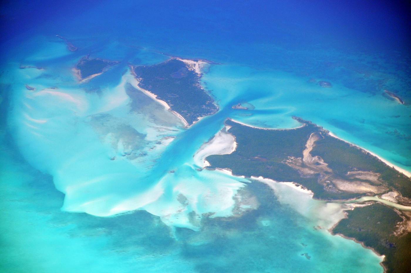
A cut is a gap between cays, the place where a boat passes from one side of the chain to the other. Two things decide whether it is a calm transit or a rough one: the water moving through it and the swell arriving at it. This page covers both and is part of the boating guide.
How do tides work at an Exuma cut?
The tidal range in The Bahamas is about 2.5 to 3 feet, according to The Moorings eGuide5. The same guide says the water is shallow enough that close attention to the tide is extremely important underway and when entering or leaving harbours5. The Moorings also says Exuma waters require attention to reef locations and tides2.
A cut is a constricted channel, and the timing there is not what a tide table suggests. In constricted water, slack water does not occur at high and low water6. In some places the ebb may run for up to three hours after the water level has started to rise6. In many locations one tidal stream is also stronger than, and lasts longer than, the stream in the opposite direction six hours later6. High and low tide times alone will not tell you when the water stops moving.
When is the best time to run a cut?
At slack water. Slack tide is the short period when a tidal stream has no movement either way, just before it reverses6. Difficult channels are more safely navigated at slack water, because any flow may set a vessel out of the channel into danger6. A favourable flow raises your speed over the bottom for a given speed through the water6. Slack water can be estimated from a tidal atlas or the tidal diamonds on a nautical chart6.
NOAA’s Coast Pilot gives a general rule for strong currents. Its text covers the Straits of Florida and the Gulf coast, not the Exuma cuts, so read it as a general rule. It says the velocity of the current varies greatly by locality and changes suddenly with wind and barometric pressure, so no fixed hourly rate of drift can be given7. High velocities are often carried between certain points and then drop off suddenly between others7. The same chapter says not to fix your position by ship speed plus a supposed current rate, and to check the position by bearings whenever possible7.
For that reason this page gives no current speed or tide time for any named cut. Use current tide tables and the chart for the day you go, and plan to transit difficult channels at slack water.
What time is low tide today in Exuma?
Look it up for the day and the place. Bahamas Met publishes a Sun Moon Tides Table for 20269. The Moorings names windfinder.com, tide-forecast.com and windy.com for tide and wind checks5. Tide times and swell are separate questions, so you need an answer to both.
Can swell make a cut dangerous when the wind is light?
Yes. Bahamas Met issued a special weather statement on a cold front at 6 PM EDT on Saturday 17 October 2026, and its headline warned of large northeast swells and hazardous marine conditions through midweek8. Four lines of the statement matter to anyone planning a cut.
| Bulletin item | What it says |
|---|---|
| Breaking swell | Swells will break heavily across reefs, cuts and harbour entrances1 |
| Seas | 7 to 11 feet on the Atlantic exposures of the Central and Southeast Bahamas, Monday through Tuesday1 |
| Local winds | Only 10 to 15 knots over the same days1 |
| Small craft | Operators in the Central and Southeast Bahamas should remain in port or stay in sheltered waters, Monday through Tuesday1 |
The same statement that put local winds at 10 to 15 knots put seas at 7 to 11 feet1. The wind forecast alone did not describe the sea.
What should I take from that bulletin?
Read the swell line, not only the wind line. A cut can be rough on a day when the local wind forecast looks easy1.
Treat “reefs, cuts and harbour entrances” as a list of places where swell breaks. The bulletin names them together1. If swell is breaking heavily at these places, wait for a better day.
Take the small craft advice at face value. Waiting a day is a legitimate plan, and it costs less than a bad crossing.
For how fronts shape a whole trip rather than a single crossing, read the weather windows guide. To decide which side of the chain you want to be on before you reach a cut, read Exuma Bank vs Exuma Sound.
What are the rules once you come through?
Inside Exuma Park, all vessels, including dinghies and jet skis, must operate at idle speed in any mooring field or anchorage3. The north tidal creek on Shroud Cay is a strict idle speed, no wake zone, and motorized vessels are prohibited from entering any of the other tidal creeks in Shroud Cay3. The rest is in the park rules.
Which VHF channels matter near the cuts?
Channel 16 is monitored 24 hours a day for emergencies, and the Bahamas Defence Force can be contacted on VHF 164. Call “Exuma Park” on channel 09 to reach the park office4. The office sits on a remote small island, so contacting it can sometimes be challenging4. The VHF channels guide lists the channels cruisers use along the chain.
These pages are not a substitute for charts, forecasts and local knowledge.
Read next
Exumas weather for boaters: trade winds, cold fronts, swell and hurricane season
Exumas boating weather: hurricane season dates, how each source describes the trade winds, and how a cold front and its swell show up in a Bahamas Met bulletin.
boatingVHF Channels in the Exumas: Exuma Park, Emergencies and Marina Calls
Which VHF channels to use in the Exumas: Exuma Park on 09, emergencies and the Defence Force on 16, marina calls, and how to reach the park office.
boatingExuma Park moorings: how to get a ball, call ahead and pay
Exuma Cays Land & Sea Park takes no mooring reservations. How to get a ball at Warderick Wells and the other fields, when to pay, what it costs and who to call.
Questions people ask
What should I check before running an Exuma cut?
Check the tide, the swell and the wind. Exuma waters need attention to reef locations and tides2, and The Moorings asks for close attention to the tide while underway and entering or leaving harbours5. On 17 October 2026 Bahamas Met warned that swells would break heavily across cuts1.
When is the best time to go through a cut?
Wikipedia notes that difficult channels are more safely navigated at slack water, because any flow may set a vessel out of the channel6. Slack water, in constricted water especially, does not fall at high or low water, so work it out from a tidal atlas or the tidal diamonds on the chart6.
What time is low tide today in Exuma?
Use a current tide table for the day you go. Bahamas Met publishes a Sun Moon Tides Table for 20269, and The Moorings names windfinder.com, tide-forecast.com and windy.com for tide and wind checks5. This page gives no tide times.
Can a light wind forecast still mean rough water?
Yes. Bahamas Met forecast seas of 7 to 11 feet on Atlantic exposures of the Central and Southeast Bahamas from Monday through Tuesday, even though local winds would be only 10 to 15 knots1.
Sources (9)
- Special Weather Statement, cold front update, issued 6 PM EDT Sat 17 Oct 2026 (PDF)GOV
Bahamas Department of Meteorology · met.gov.bs · checked 2026-10-18 - Exumas Yacht Charters & Sailing VacationsOPERATOR
The Moorings · moorings.com · checked 2026-10-18 - Exuma Cays Land and Sea Park Rules (PDF)BNT
Bahamas National Trust · bnt.bs · checked 2026-10-18 - Exuma Cays Land & Sea ParkBNT
Bahamas National Trust · bnt.bs · checked 2026-10-18 - The Moorings Exumas eGuide 2026 (PDF)OPERATOR
The Moorings · assets.moorings.com · checked 2026-10-19 - Slack tide (Wikipedia)
Wikipedia · en.wikipedia.org · checked 2026-10-19 - U.S. Coast Pilot 5, Chapter 3 (Gulf Coast, Straits of Florida), edition 11 OCT 2026GOV
NOAA Office of Coast Survey · nauticalcharts.noaa.gov · checked 2026-10-19 - Bahamas Department of Meteorology home page (special weather statement headline, 17 Oct 2026)GOV
Bahamas Department of Meteorology · met.gov.bs · checked 2026-10-19 - Sun Moon Tides Table 2026 (Bahamas Met page)GOV
Bahamas Department of Meteorology · met.gov.bs · checked 2026-10-19
Photo credits (2)


Park fees and rules come from the Bahamas National Trust or the Bahamas government; check them again before you go. How we check facts.