Hurricane season in the Exumas: dates, peak and what past storms did
Exumas hurricane season for boaters: June 1 to November 30 dates, the September 10 peak, average storm counts, what Joaquin did to Exuma and NHC marine rules.
The Atlantic hurricane season that applies to boating in the Exumas runs from June 1 to November 30, per the US National Hurricane Center1. The Center puts the peak at September 10, with most activity between mid-August and mid-October1. An average season brings 14 named storms, 7 hurricanes and 3 major hurricanes1.
- At a glance
- Season
- June 1 to November 301
- Peak
- September 101
- Most activity
- Mid-August to mid-October1
- Average season
- 14 named storms, 7 hurricanes, 3 major1
- Past storm
- Hurricane Joaquin, October 20152
- NHC advisories
- 4 a day while a system is active3
On this page
Anyone planning a boat trip to the Exumas between summer and early winter plans around hurricane season. The dates, averages and boating rules below come from the US National Hurricane Center (NHC) and the Bahamas Department of Meteorology. For day-to-day wind and sea conditions, see the weather windows guide, and for the wider boating picture the boating hub.
When is hurricane season in the Exumas?
The Atlantic hurricane season runs from June 1 to November 30, and activity sometimes occurs before and after those dates1. The NHC calls a tropical cyclone a hurricane once its maximum sustained winds reach 74 mph (64 knots), and a major hurricane at 111 mph (96 knots) or higher1.
The NHC describes an average season, measured over 1991 to 20201, like this:
| Milestone in an average season | When |
|---|---|
| First named storm | Mid to late June (about June 20)1 |
| First hurricane | Early to mid-August (about August 11)1 |
| First major hurricane | Late August or early September (about September 1)1 |
| Peak of the season | September 101 |
| Most activity | Mid-August to mid-October1 |
| 13th named storm | About October 251 |
| 14th named storm | About November 191 |
The late rows matter if you plan an autumn passage. By the beginning of September an average year has produced four named systems, but the average count reaches 14 only in the third week of November1. Individual seasons vary considerably from these dates1.
How many storms does an average season bring?
An average Atlantic hurricane season has 14 named storms, 7 hurricanes and 3 major hurricanes1. The NHC adds that by the beginning of September an average year has had four named systems, two of them hurricanes and one a Category 3 or stronger1. A quiet count across the basin does not mean a quiet week at your anchorage, so check the forecast for the days you are on the water.
Does Exuma get hit by hurricanes?
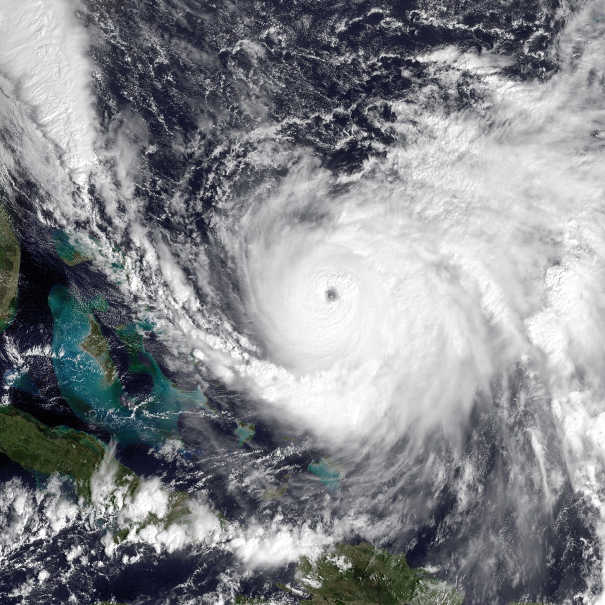
Yes. Hurricane Joaquin reached Category 4 in October 2015, and its winds and storm surge devastated Crooked Island, Acklins, Long Island, Rum Cay and San Salvador2. The NHC calls it the strongest October hurricane known to have affected the Bahamas since 18662. It strengthened fast: a 60-hour period of rapid intensification began on 29 September2.
For the Exumas, the NHC’s report says sustained hurricane-force winds likely affected the southern Exumas, and sustained tropical-storm-force winds affected the rest of the chain2. Its damage summary for Exuma lists extreme flooding and downed power lines2. Storm surge reached 12 to 15 feet on Rum Cay, Crooked Island and Acklins, according to the Bahamas Department of Meteorology2. Damage in the Bahamas was estimated at well over $60 million2.
Joaquin also shows what the sea does to ships. It took 34 lives, all at sea, including the 33 crew of the cargo ship El Faro2. The lesson for a private boat is the one the NHC gives mariners: there is no single rule of thumb for staying safe from a hurricane, only constant monitoring and repeated risk analysis3.
What does the National Hurricane Center tell boaters to do?
The NHC’s marine safety page sets out rules that apply to a boat in the Exumas as much as to a ship.
NHC guidance: “avoiding the 34 KT wind field of a hurricane is paramount” for vessels at sea3.
- Update your plan with every advisory. When a system is active the NHC issues four forecast/advisory messages a day, and the risk analysis should be redone with each one3.
- Use the 1-2-3 rule. Allow a 100-mile error radius on the 24-hour forecast, 200 miles at 48 hours and 300 miles at 72 hours3.
- Never cross the track. The NHC says never to plan to cross the “T” of a hurricane3.
- Keep a second option. Never leave yourself with only a single navigation option3.
- Decide early. The decision to leave port must be made very early, because vessels that made the right decision too late were still damaged or lost3.
Is a dock or marina safe in a storm?
Not automatically. The NHC warns that storm surge can lift a vessel out of a protected wind and wave regime into water exposed to far stronger winds and waves3. Many Caribbean docks are fixed, built for a small tidal range, and can be submerged by even minimal hurricane surge3. Line strain climbs quickly too: the force on a moored vessel nearly doubles for every 15 knots of wind between tropical storm force (34 knots) and hurricane force (64 knots)3.
How do you follow a storm?
The NHC publishes forecasts and advisories at nhc.noaa.gov3. The Bahamas Department of Meteorology carries a Hurricanes/Tropical Storms page and the marine forecast at met.gov.bs4. For radio contacts on the water, see the VHF channels guide.
If you are choosing a month rather than a boat plan, the best time to visit the Exumas page sets hurricane season against the rest of the year.
Read next
Exumas weather for boaters: trade winds, cold fronts, swell and hurricane season
Exumas boating weather: hurricane season dates, how each source describes the trade winds, and how a cold front and its swell show up in a Bahamas Met bulletin.
planBest time to visit the Exumas: weather, hurricane season and events
When to go to the Exumas: the November to April dry season, the June to November hurricane season, Nassau rain and temperature by month, and April's regatta.
boatingVHF Channels in the Exumas: Exuma Park, Emergencies and Marina Calls
Which VHF channels to use in the Exumas: Exuma Park on 09, emergencies and the Defence Force on 16, marina calls, and how to reach the park office.
Questions people ask
When is hurricane season in the Exumas?
The Atlantic hurricane season runs from June 1 to November 301. The National Hurricane Center says tropical cyclone activity sometimes occurs before and after those dates1.
Does Exuma get hit by hurricanes?
Yes. Hurricane Joaquin's sustained hurricane-force winds likely reached the southern Exumas in October 2015, and the rest of the chain saw tropical-storm-force winds2. The Hurricane Center's report lists extreme flooding and downed power lines on Exuma2.
When is the peak of hurricane season?
September 10 is the peak of the Atlantic season, and most activity falls between mid-August and mid-October1. In an average year the first hurricane forms on about August 11 and the first major hurricane on about September 11.
How many hurricanes does an average Atlantic season bring?
An average Atlantic season, measured over 1991 to 2020, has 14 named storms, 7 hurricanes and 3 major hurricanes, according to the National Hurricane Center1.
When should a boat leave port ahead of a hurricane?
Early. The National Hurricane Center says the decision to leave port for hurricane avoidance must be made very early, and some vessels that left too late were still damaged or lost3.
Sources (4)
- Tropical Cyclone Climatology (NHC)GOV
US National Hurricane Center (NOAA) · nhc.noaa.gov · checked 2026-10-24 - Tropical Cyclone Report: Hurricane Joaquin (AL112015), 12 January 2016 (PDF)GOV
US National Hurricane Center (NOAA) · nhc.noaa.gov · checked 2026-10-24 - Marine Safety: hurricane guidance for marinersGOV
US National Hurricane Center (NOAA) · nhc.noaa.gov · checked 2026-10-24 - Bahamas Department of MeteorologyGOV
Bahamas Department of Meteorology · met.gov.bs · checked 2026-10-24
Photo credits (1)
- NOAA, provided via the US Navy / Wikimedia Commons · Public domain · source

Park fees and rules come from the Bahamas National Trust or the Bahamas government; check them again before you go. How we check facts.